Mapping the spread of pig disease in real-time
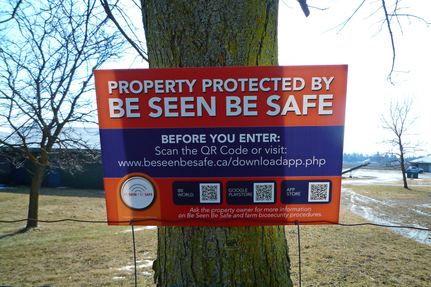
Biosecurity is becoming increasingly a matter of knowledge. Knowing how pathogens behave for one; several new Canadian IT solutions help map where pathogens are in real-time and make quick risk assessments. This way, pig producers can be better prepared for what might be around the corner.
Two new patented biosecurity systems, one for halting disease outbreaks and one for better protecting herd health, have been introduced to officials in the United Kingdom, having already been successfully rolled out over the winter in Ontario, Canada.
Presentations on ‘Be Seen, Be Safe’ and ‘Farm Health Monitor’ were recently given by Canadian inventors Tim Nelson and Joel Sotomayor to the UK Pig Health and Welfare Council and other UK livestock and poultry groups, with further meetings planned. Nelson was also invited recently to present on the systems at Canada’s Prairie Swine Centre in Saskatoon, SK, Canada.
Nelson developed the systems because he wanted better disease management to be available to the industry. Swine disease risk remains strong. Dozens of people have already died of swine flu this year in Ukraine, Russia and Armenia. The European Commission reports that there is a “permanent risk of introduction of African Swine Fever into the EU from Russia and Belarus, which has led to the expected introduction towards the west in Estonia, Latvia, Lithuania and Poland.” In addition, Porcine Epidemic Diarrhoea (PED) has been causing serious problems in Russia and Eastern Europe, with one expert stating recently that within the next 10 years there is an 80% chance of the European swine industry being hit by such a disease.
How it works to contain outbreaks
To effectively contain an outbreak, farms must be quickly quarantined and traffic to and from infected or potentially-infected farms must quickly be tracked. However, using the telephone or emails to do this has its limitations, especially in quickly identifying individuals or vehicles that may have spread the disease. Using farm visitor log books to track movement is slow to the point of being almost pointless in an emergency. This is why Nelson created ‘Be Seen Be Safe’ (BSBS) – to provide the industry with a way to instantly analyse farm visit data so that outbreaks can be rapidly contained.
Mapping farm boundaries
Before the system is turned on in any jurisdiction, the geographical boundary of each swine farm is mapped with GPS technology called ‘geo-fencing.’ During the same period of time, anyone who regularly visits swine farms – veterinarians, feed and gilt delivery persons, vaccination crews, salespersons and so on – downloads the encrypted BSBS smart phone app.
Farmer gets instant notification of farm visitors
The system then goes live. Anytime a system-ready smartphone or tablet (or the GPS beacon on vehicles that regularly travel to farms) enters a geo-fenced swine farm property, BSBS is automatically triggered and the visitor is ‘greeted’ with a welcome message. At the same moment, the farmer is instantly notified of a visitor’s arrival (information on all visits to that farm is stored in an online visitor record book which farmers can access at any time using a secure personal login). The encrypted BSBS database stores farm visit information for one year, which includes farm ID, visitor ID, number of farms visited in the recent past (a risk assessment level), time in and time out.
Geo-fencing
“The geo-fencing aspect of the system means that only on-farm visits are logged, not every movement of an individual or vehicle, which protects personal privacy,” Nelson explains. “In addition, the identity of individual visitors and farms are only accessed by authorised system administrators in an emergency outbreak situation.”
Immediate analysis of farm data in the event of an outbreak
When an outbreak hits, the BSBS software analyses the entire database of visitor and vehicle movements at lightning speed, starting with a specific flagged farm. Disease spread is mapped and extrapolated in real time, with factors like wind speed and direction, humidity and temperature added to the map. Farmers and visitors are immediate notified by text message that there is a problem, and asked to implement quarantine and other biosecurity measures.
Already roll out in Canada
‘Be Seen, Be Safe’ has been rolled out in Ontario over the winter on poultry farms, with the involvement of over 800 geo-fenced farms and over 1,200 people and vehicles. Every producer belonging to Egg Farmers of Ontario, the Ontario Broiler Hatching Egg & Chick Commission and the Turkey Farmers of Ontario are taking part. These associations have paid the first two years’ nominal cost for each farm for initial geo-fencing and monitoring, with 75% of that cost being reimbursed by a Canadian government grant. Nelson says support for the system has been overwhelming in Ontario, with everyone understanding that BSBS is no more intrusive than what came before (physically signing a farm visitor log book).
The BSBS app is available on all three main smartphone platforms: BlackBerry, Android and IOS. It causes no battery drain and involves very minimal internet usage as it only runs for a split-second when the device carrying the app crosses a geo-fenced property.
Psychology of biosecurity
Prairie Swine Centre president and CEO Lee Whittington says BSBS fits well with the psychology of biosecurity of the pork industry. “It’s one more line of defence, and helps to take the cumbersomeness out of a biosecurity system,” he observes. “The tedious manual log book system is often inaccurate and there is an immediate benefit for the producer in that BSBS provides a permanent, accurate record of who visited the farm.” Whittington also sees another benefit in the system, relating to the fact that farm ownership in Canada and other places has changed. “It used to be that the family farm was one farm entered through one gate,” he says, “but now farms have multiple sites and it’s much harder to keep an eye on things.”
Whittington believes this type of technology represents what’s happening in other segments of society and industry sectors. “Geo-fencing existed, but Tim put the pieces together,” he notes. “Everyone has smart phones now and this system uses them but protects overall privacy. The mentality today is ‘I want the data immediately and at little or no cost,’ and ‘Be Seen, Be Safe’ fits with that.”
Farm Health Monitor
Nelson and Sotomayor have also developed ‘Farm Health Monitor’ (FHM), which permits all farmers and veterinarians in a given area to better contain and manage production-limiting diseases. Like BSBS, FHM also involves a secure smart phone app where farmers and veterinarians can input information on disease symptoms and/or animal deaths. If similar information is reported on two or more farms within a given area, FHM sends out a blanket warning across the region, prompting producers and vets to check flocks and herds carefully and to report as necessary. Nelson calls it ‘a true early warning system’. A poultry FHM app is being trialled right now, with the swine version ready for trial and a dairy version under development. The ability to upload a short video is being added.
More information: https://beseenbesafe.ca/ or www.farmhealthmonitor.com.


